


The Meteorology, Climatology, and Geophysics Agency (BMKG) has issued a warning of an increased likelihood of tropical cyclone formation in southern Indonesia. Atmospheric monitoring indicates that cyclone seeds may develop between November 2025 and February 2026 in several vulnerable waters. This risk requires public attention amid the recent escalation of extreme weather. The situation calls for stronger anticipatory measures from both the government and the public.
Responding to the hydrometeorological disasters that struck Aceh, North Sumatra, and West Sumatra in late November, the Head of BMKG and Professor at the Faculty of Engineering, Universitas Gadjah Mada (FT UGM), Professor Teuku Faisal Fathani, emphasized that early warnings had been issued several days beforehand.
The information had been delivered to local governments, the Regional Leadership Coordination Forum (Forkopimda), and the Regional Disaster Management Agency (BPBD) to accelerate field response. Several regional leaders promptly informed their communities about potential hazards through their communication channels.
“We continue to update this every two days due to the extreme weather potential in these three regions,” Professor Fathani said in a meeting with Commission V of the House of Representatives (DPR RI) on Monday (Dec. 1).
Professor Fathani explained that global atmospheric anomalies have increased the likelihood of cyclone seed formation in Indonesia.
Phenomena such as La Niña, El Niño, the Indian Ocean Dipole, and Siberian cold surges have heightened weather instability. These shifting patterns mean that tropical regions historically less affected by cyclones are now facing greater risk.
“This is what triggers the development of new cyclones across Indonesian waters,” he said.
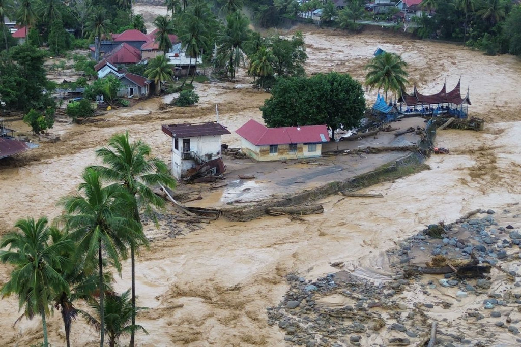
He highlighted Cyclone Senyar, which brought extreme rainfall to Aceh and North Sumatra as it moved erratically and remained trapped over the Malacca Strait.
The slow movement caused rain clouds to form and persist over the exact locations for 2 to 3 days. Warm sea surface temperatures further intensified cloud formation.
“Because it circulated for too long, the extreme rainfall persisted for up to three days,” Professor Fathani explained.
For the period from December through February, BMKG predicts an increased potential for tropical cyclone seed formation in southern Indonesian waters.
High-risk areas include Bengkulu, southern Sumatra, southern Java, Bali, Nusa Tenggara, Maluku, and central to south Papua. Densely populated regions are urged to exercise heightened caution should cyclones intensify.
“These are the areas prone to developing cyclone seeds that may grow into tropical cyclones,” he said.
Professor Fathani urged the public to strengthen mitigation efforts in anticipation of extreme weather in the coming months. Routine monitoring of early warnings is essential to minimize the impact of disasters.
Local governments are also expected to ensure that basic infrastructure, such as drainage systems, evacuation routes, and public facilities, is ready.
“Vigilance needs to be increased because the peak of the rainy season is in January and February,” he stated.
BMKG and the National Disaster Management Agency (BNPB) are currently conducting weather modification operations in several affected areas to support evacuation and aid distribution.
These efforts aim to divert or disperse rain clouds to prevent worsening conditions in disaster zones. Similar programs have been implemented in other areas, such as Mount Semeru and Lake Toba, which face ongoing risks due to shifting weather patterns.
“The key goal is to ensure that rescue operations and aid distribution remain unhindered by weather conditions,” Professor Fathani concluded.
Author: Triya Andriyani
Post-editor: Rajendra Arya
Source: YouTube Channel of DPR RI
Photograph: Kompas