

A research team from Universitas Gadjah Mada (UGM) has developed a spatial data-based Disaster Basic Information Geoportal to support disaster response efforts in Sumatra. The disaster information maps were created to address the urgent need for spatial data, including needs maps, affected area maps, and rapid damage assessment maps during the emergency response phase.
The Dean of UGM Faculty of Geography (Geography UGM), Professor Muhammad Kamal, emphasized that the initiative emerged from a long-standing issue in disaster management, namely the unequal distribution of aid.
“In many disaster events, aid distribution is often uneven because accurate spatial data does not support it. We want to change this pattern from assumption-based to data-driven,” Professor Kamal said on Saturday (Jan. 3).
The Disaster Basic Information Geoportal team consists of volunteers from Geography UGM, the Geodetic Engineering Program of the UGM Faculty of Engineering (FT UGM), and the Geographic Information Systems Program of the UGM Vocational College (SV UGM).
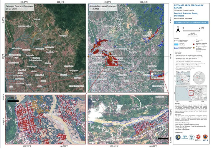
The team produced six map outputs: a map of the status of health facilities and shelters, a map of affected settlements, a needs map, a flood-affected area map, a before-and-after flood comparison map, and a road network accessibility map.
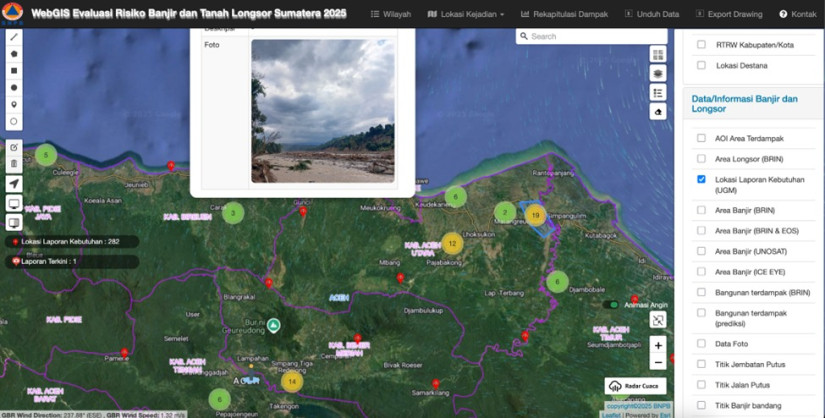
The Vice Dean of Geography UGM, Dr. Sigit Heru Murti Budi Santosa, explained that the faculty acts as both the initiator and technical coordinator in developing a participatory WebGIS platform based on crowdsourcing.
“We developed the WebGIS so that affected communities can directly report their needs, complete with location and contact person details. Lecturers and students on campus serve as the ‘data kitchen’ to verify these reports,” Dr. Santosa explained.
He added that the development of this system is not new. Participatory mapping models have been applied since the 2006 Bantul earthquake and later continued during the Lombok earthquake, as well as the Palu earthquake and tsunami.
Meanwhile, another member of the research team from Geography UGM, Dr. Nur Mohammad Farda, explained that the volunteer team also received support for high-resolution satellite imagery from the United Nations Disaster Charter, in collaboration with BRIN, to rapidly map damage levels.
“We interpreted satellite imagery from the Disasters Charter portal to identify flood-affected settlements and quickly map damage levels during the emergency phase,” Dr. Farda explained.
The results of the needs mapping were subsequently adopted by the National Disaster Management Agency (BNPB) through the InaRISK WebGIS Dashboard. The needs map was first released on Dec. 6, 2025, and within 12 hours had received 54 reports from disaster-affected locations.
“Crowdsourcing methods are the most effective at the quick response stage, as victims can directly report what they need and where they are. This allows aid to be distributed accurately and monitored spatially and in real time,” Professor Kamal added.
During implementation, the team faced technical challenges with data validation and the timeliness of information. Data sourced from the public is highly vulnerable to hoaxes and duplication, making it essential that all reports be verified before they are displayed on the main map.
To produce this spatial data-based disaster mapping, Professor Kamal acknowledged that contributions from lecturers and students across various mapping teams were crucial.
“Students not only learn GIS, remote sensing, and cartography in the classroom, but also apply these skills directly to save lives. This is our contribution, in line with our academic expertise, to support disaster response efforts in Sumatra,” he concluded.
Author: Jelita Agustine
Editor: Gusti Grehenson
Post-editor: Rajendra Arya
Photographs: Disaster Information Geoportal Team