• News Archive
  • Simaster
  • Webmail
  • Directory
  •  English
    • Indonesia
Universitas Gadjah Mada Universitas Gadjah Mada Universitas Gadjah Mada Universitas Gadjah Mada
  • Education
    • Doctoral dissertation
    • Inauguration of Professor
    • Graduation
  • Achievement
  • Research and Innovation
    • Research
    • Innovation
  • Campus Info
    • Cooperation
    • Seminar and Workshop
    • Student Community Service Program
    • Other
  • News Report
  • Home
  • News Report
  • Optimising Geospatial Information

Optimising Geospatial Information

  • 20 November 2017, 13:54 WIB
  • By: Marwati
  • 1167
  • PDF Version
Mengoptimalkan Teknologi Geospasial

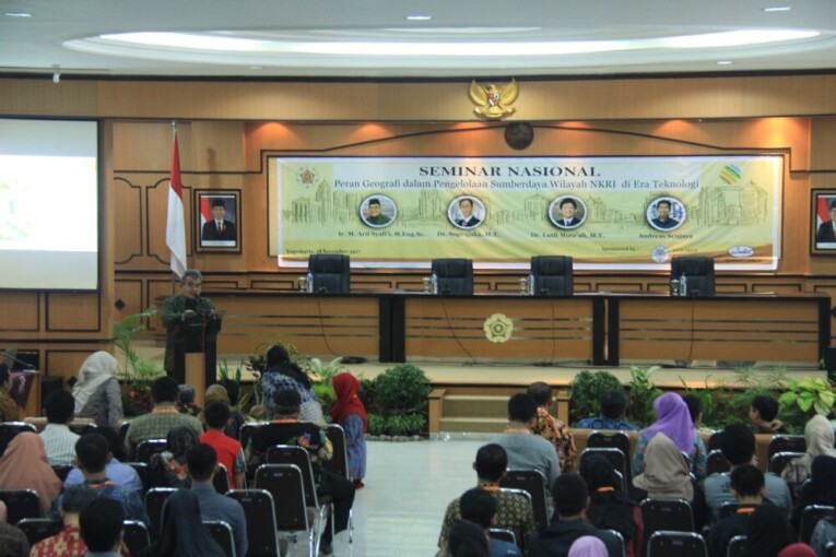
Graduate geography students at Faculty of Geography, Universitas Gadjah Mada, hosted a national seminar themed the Role of Geography in Resource Management in Indonesia in the Technology Era on Saturday (18/11) at Faculty of Geography UGM. Keynote speakers of the seminar include Ir. M. Arief Syafi’i, M.Eng.Sc. (Deputy Head of Geospatial Information of Geospatial Information Agency), Dr. Suprajaka, M.T. (Head of Standardisation of Geospatial Information Agency), Dr. Luthfi Muta’ali, S.Si., M.S.P. (spatial development expert), and Andreas Senjaya (Co-Founder & CEO of iGrow).

Arief Syafi’i explained geospatial information was the object of interest from different sectors. As high as 65% government activities use spatial element as the main identifier while as much as 90% of government activities have spatial element.

“Geospatial information allows the user to know that each object is in one place and each activity or event happens in one place,” said Arief.

Arief explained geospatial element of an information is used as core identifier to integrate information. The implication of the information can produce analysis that is sharper and more comprehensive.

“Implication of all data and information can be integrated to resolve problems more comprehensively, faster and better,” Arief said.
Arief further highlighted the use of geospatial technology. Geospatial technology is a technology that relates to collection of data on location, such as Global Navigation Satellite Systems (GNSS), Remote Sensing, and Geography Information System. Geospatial technology has many benefits including to collect and process data faster and accurately.

Meanwhile, Suprajaka highlighted the increase in human resource competence that is based on geographic information system. Suprajaka explained there were many things to be done to enhancing national geography information infrastructure.

“These include regulatory policy, institutional, technology, human resource (acceleration of certification for Geospatial Information profession), and geospatial information standard,” he said.


Related News

  • Geospatial Information Map of Indonesia Not Yet Adequate

    Tuesday,16 May 2017 - 14:00
  • Indonesia Still Lacks Geospatial Information Human Resource

    Thursday,24 November 2016 - 10:13
  • Faculty of Geography UGM and BIG Socialise Competence and Qualification Standards

    Thursday,17 May 2018 - 8:42
  • Earth Map in Scale of 1:1000 is Still Lacking

    Tuesday,07 June 2011 - 14:55
  • Coastal and River Basin Management Needs to Involve Stakeholders

    Friday,13 May 2016 - 10:04

News Releases

  • Agricultural Engineering Students Grab Medals at 2022 AE-ARC 20 May 2022
    UGM Agricultural Engineering students won four medals and
    Salma
  • UGM Students Win International Chess Tournament 19 May 2022
    UGM representatives have been named winners at the 25th GA
    Salma
  • UGM Researchers Breed New Black Soybean Cultivar 17 May 2022
    A team of researchers at the UGM Faculty of Agriculture is
    Salma
  • UGM Inaugurates New Professor of Chemical Engineering 13 May 2022
    Universitas Gadjah Mada (UGM) celebrated the promotion of
    Salma
  • UGM Among World’s 10 Best Universities to Deliver SDG 1 10 May 2022
    Universitas Gadjah Mada (UGM) was ranked in the top 10 glo
    Salma

Info

  • Install Fest Windows
    29 September 2017
  • Streaming Author Workshop Writing and Publishing
    14 July 2017
  • Hokkaido University Short Term Exchange Program HUSTEP
    08 January 2016
  • 2016 Amgen Scholars Program in Japan
    08 January 2016
  • Jardine Foundation Scholarship for Postgraduate Studies at University of Oxford and University of Cambridge
    01 July 2015

Event

  • 30May International Academic Conference on Tourism (INTACT) 2022 ...
  • 21Jul The International Conference on Sustainable Environment, Agriculture, and Tourism (ICOSEAT)...
  • 07Sep The 8th International Conference on Science and Technology (ICST 2022)...
Universitas Gadjah Mada
UNIVERSITAS GADJAH MADA
Bulaksumur Yogyakarta 55281
   info@ugm.ac.id
   +62 (274) 588688
   +62 (274) 565223
   +62 811 2869 988

PARTNERSHIP

  • Alumni
  • International Affairs

ABOUT UGM

  • Rector's Welcome
  • History
  • Vission and Mission
  • The Board of Executive
  • Management

VISIT UGM

  • Campus Map
  • Event

REGISTRATION

  • Undergraduate
  • Graduate
  • Vocational School
  • Professional Program
  • International Program

© 2022 Universitas Gadjah Mada

PRIVACY POLICYCONTACT