

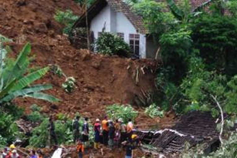
The threat of a flash flood caused by the formation of a landslide dam has become the main focus of the Geological Team of the Disaster Emergency Response Unit, Universitas Gadjah Mada (DERU UGM). DERU UGM collaborates with personnel from the District Military Command (Kodim) and the Regional Disaster Management Agency (BPBD).
The warning was issued after they discovered several new active fractures and a high-discharge spring (0.2 m³/second) at the hilltop of the landslide site in Pandanarum Village, Pandanarum District, Banjarnegara Regency. These findings indicate that the slope body is experiencing extreme water saturation, which could trigger sudden mass movement.
UGM Geological Expert, Professor Dwikorita Karnawati, emphasized that water from the newly emerging spring could accumulate behind the old landslide deposits, forming a natural pond that may burst at any time.
“The threat of secondary landslides continues to loom over the residents of Pandanarum Village, and the risk of a flash flood has now increased significantly,” she said on Sunday (Nov. 23).
According to Professor Karnawati, the new fractures accelerate the infiltration of rainwater into the soil mass on the slope. As pore water pressure rises, previously stable material may be pushed downward and block the small stream at the foot of the slope.
This condition represents a classic scenario for the formation of a landslide dam prone to sudden failure. If the dam wall cannot withstand the rising water volume, an abrupt release could trigger a high-velocity flood surge toward settlements in the lower zone.
“If the landslide dam collapses, the flow will carry not only mud but also the entire previous landslide material,” she explained.
If this occurs, Professor Karnawati estimates the impact could be far more extensive and destructive than the initial landslide, driven by water pressure from a pond the size of a football field, with an estimated depth of 1.5 meters.
The danger is further intensified by the presence of a blue clay layer beneath the fracture zone, dipping outward from the slope.
This layer contains clay minerals such as montmorillonite, smectite, and illite, which are highly prone to swelling when exposed to water. When dry, the layer is as hard as rock; when saturated, it transforms into a toothpaste-like, highly slippery material.
“This blue clay, known in geological terminology as shale, makes the overlying soil mass extremely mobile and accelerates repeated landslides. Once saturated, its strength drops drastically,” Professor Karnawati stated.
It is this blue clay layer, according to Professor Karnawati, that explains why ground movement in Pandanarum has not stopped (even after the major landslide) and continues to increase.
The combination of new fractures, high-discharge springs, and the blue clay layer has rendered the slope extremely unstable. In light of these conditions, the UGM Geological Team concludes that the top priority is to prevent additional water accumulation behind the landslide deposits.
“Emergency measures such as creating a bypass channel through the landslide material as a temporary drainage route are crucial to reducing water pressure. Without such action, the risk of landslide dam failure will continue to rise sharply,” she stressed.
She also urged residents to avoid activities at the base of slopes, riverbanks, narrow valleys, and along any water flow paths that could become flash-flood routes. With high rainfall in recent days and the strong discharge from springs near the crown of the landslide, pore water pressure within the slope is expected to keep increasing.
“Safety must come first. Stay away from the lower slope area and immediately report any new fractures or unusual water flow. The danger in Pandanarum is not only the landslide itself but also the threat of sudden flash floods,” she concluded.
Author: Agung Nugroho
Post-editor: Rajendra Arya
Photograph: Kompas