


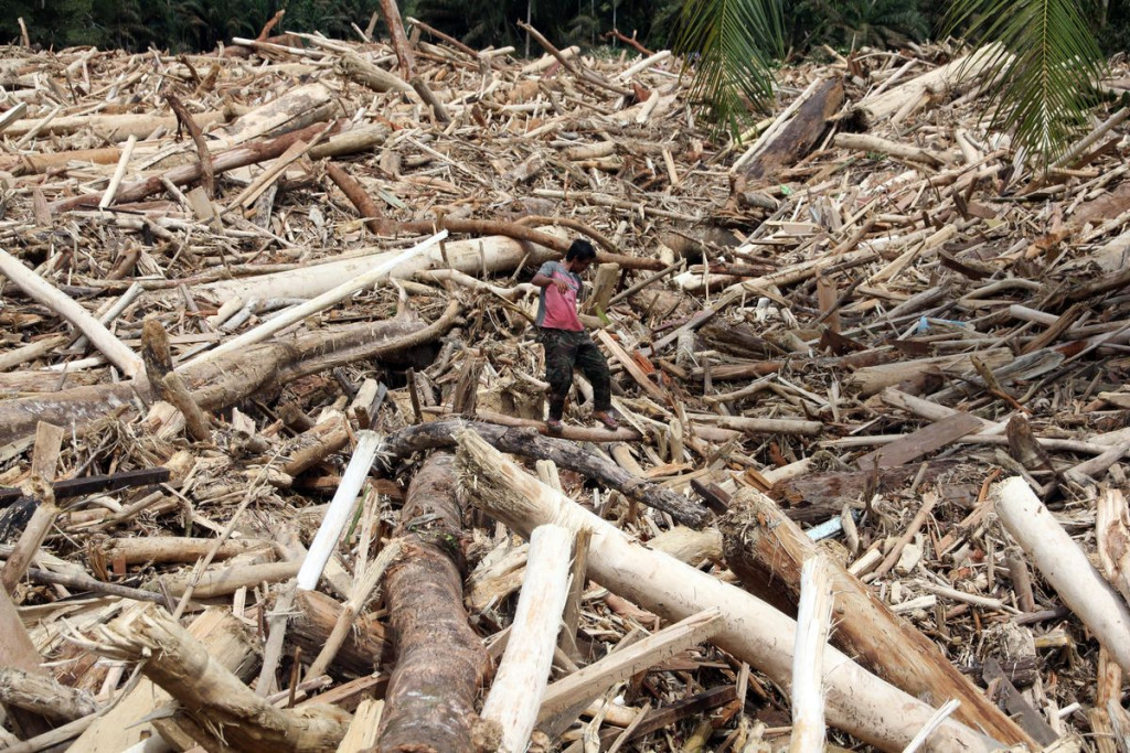
The flash floods and landslides that struck West Sumatra, North Sumatra, and Aceh in late November 2025 left an extraordinary trail of destruction. Days of continuous heavy rain caused rivers to overflow and hillsides to collapse. Hundreds of villages were inundated, vital infrastructure was cut off, and the floods claimed hundreds of lives.
The National Agency for Disaster Management (BNPB) recorded 2,726 hydrometeorological disasters from early 2025 through November, with the late-November flash floods alone causing more than 400 deaths across the three affected provinces. The Governors of West Sumatra, North Sumatra, and Aceh simultaneously declared a 14-day emergency response period starting at the end of November 2025.
Dr. Hatma Suryatmojo, a Hydrological and Watershed Conservation Researcher at UGM, stated that the flash floods at the end of November 2025 were not an isolated event. Experts view them as part of a recurring pattern of hydrometeorological disasters that have intensified over the past two decades. They arise from a combination of natural factors and human activity.
“Rainfall was extremely high at the time. The Meteorology, Climatology, and Geophysics Agency (BMKG) recorded daily rainfall exceeding 300 millimeters in parts of North Sumatra during the peak of the event. This extreme rainfall was triggered by extraordinary atmospheric dynamics, including Tropical Cyclone Senyar, which formed in the Malacca Strait in late November 2025. However, extreme weather was only the initial trigger. The destructive impact was greatly exacerbated by the weakened natural defenses in the upper watershed,” Dr. Suryatmojo said at the UGM Campus on Monday (Dec. 1).

According to Dr. Suryatmojo, forest ecosystem degradation in the upper watershed reduced the area’s ecological capacity to absorb and regulate high rainfall. The loss of forest cover means the disappearance of forest functions that regulate the water cycle through hydrological processes such as interception, infiltration, evapotranspiration, and erosion control. Without these functions, massive erosion and landslides occur, forming the precursors of flash floods.
He emphasized that forests in the upper watershed serve as critical hydrological buffers. Dense forest vegetation acts like a giant sponge, absorbing rainwater into the soil and preventing it from flowing directly into rivers. Studies in natural tropical forests in Kalimantan and Sumatra show that forest canopies can intercept 15–35 percent of rainfall.
Undisturbed soil conditions allow up to 55 percent of rainfall to infiltrate into the ground, leaving only 10–20 percent as surface runoff. Forests also return 25–40 percent of rainfall to the atmosphere through evapotranspiration.
“In this way, forests maintain the balance of the water cycle, preventing floods during the rainy season and sustaining baseflow during the dry season. On the other hand, when upper-watershed forests are degraded or cleared, the natural hydrological cycle becomes disrupted, and these functions are lost. The soil loses porosity as root networks disappear, drastically reducing water absorption. Consequently, most rainfall becomes surface runoff that rushes downstream,” he explained.
Even intact forests have limits to the amount of rainfall they can absorb. Under extreme rainfall, this capacity is overwhelmed, increasing the likelihood of landslides. Landslide debris, soil, rocks, and tree trunks can dam rivers and create temporary natural blockages.
Large volumes of rapidly accumulating water exceed the river’s capacity, and when the natural dam fails, it triggers flash floods. Soil that is no longer anchored by roots is easily eroded, sending mud and sand into rivers, where it accumulates and causes shallowing of the riverbed.
“Sedimentation narrows rivers and increases flood risks. In short, losing upper-watershed forests means losing the natural safety belt that protects downstream areas,” said the lecturer from the UGM Faculty of Forestry.
Dr. Suryatmojo expressed concern over the massive deforestation occurring in many upper-watershed regions of Sumatra. In Aceh, for example, about 59 percent of the province (±3.37 million hectares) remained natural forest in 2020. However, combined data from Statistics Indonesia (BPS) Aceh and environmental organizations show that the province lost more than 700,000 hectares of forest between 1990 and 2020.
Although Aceh still has relatively extensive forest cover, the rate of forest loss is significant, increasing flood vulnerability. Conditions are even more concerning in North Sumatra, where forest cover accounted for only about 29 percent of the land area (±2.1 million hectares) in 2020. The remaining forests are fragmented across the western Bukit Barisan mountains, including parts of Gunung Leuser National Park, and conservation enclaves such as Tapanuli.
One of North Sumatra’s last remaining forest strongholds is the Batang Toru ecosystem, which is now under severe pressure from human activities. Batang Toru has been steadily degraded by concessions and company operations ranging from illegal logging to plantation development and gold mining. Fragmented and stressed forests lose much of their ecological function in rainfall regulation and flood control.
Meanwhile, West Sumatra had approximately 54 percent forest cover (±2.3 million hectares) in 2020. Although its forest cover is higher than North Sumatra’s, the province has one of the highest deforestation rates in the country. Walhi West Sumatra reports that between 2001 and 2024, the province lost about 320,000 hectares of primary forest and 740,000 hectares of total tree cover (primary and secondary forests combined).
In 2024 alone, deforestation reached 32,000 hectares. Much of West Sumatra’s remaining forest lies on steep slopes along the Bukit Barisan range, meaning that forest loss sharply increases the risk of landslides and flash floods.
“The flash flood tragedy that struck Sumatra in November 2025 was essentially the accumulation of long-standing ‘ecological sins’ in the upper watershed. Extreme weather was only the trigger; the severity of the disaster reflected extensive environmental degradation from the headwaters to the downstream areas,” he stated.
Weak land-use planning and control, Dr. Suryatmojo argued, have enabled widespread forest encroachment, conversion of forest land into oil palm plantations, and illegal logging in the upper watershed, key drivers behind the frequent hydrometeorological disasters in the region.
Protected forests in the Batang Toru ecosystem, which should serve as vital water-catchment areas, have been converted into plantations or cleared by illegal loggers. As a result, heavy rainfall can no longer be naturally retained upstream and instead rushes directly into downstream settlements.
“The flash floods of November 2025 in Aceh, North Sumatra, and West Sumatra may be among the largest of the past several decades. These events demonstrate a worsening trend in hydrometeorological disasters as deforestation and climate change intensify,” he noted.
Geographically, Sumatra’s humid tropical climate naturally exposes it to heavy rainfall. Environmental degradation, such as upland forest clearing and river narrowing, makes the region increasingly vulnerable, like a ticking time bomb. Without significant corrective action, Dr. Suryatmojo warned, future peak rainy seasons could bring similar disasters.
“Nature has limited capacity to withstand extreme weather, and that capacity depends heavily on environmental integrity. When human activities degrade the environment beyond its thresholds, nature ‘responds’ with severe disasters. Therefore, future disaster-risk reduction must balance structural measures (technical infrastructure) with ecological approaches,” he emphasized.
Structural interventions such as levee construction, riverbank restoration, and river normalization are important but insufficient without parallel environmental conservation in the upper watershed. Dr. Suryatmojo stressed that forest protection and watershed conservation must be top priorities.
The government must enforce disaster-mitigation-based spatial planning and decisively halt deforestation in flood-prone areas. Remaining upper-watershed forests, such as the Leuser Ecosystem in Aceh and Batang Toru in North Sumatra, must be preserved as non-negotiable assets due to their irreplaceable role in preventing flash floods.
“Critical-land rehabilitation and reforestation in strategic catchment areas are urgently needed to restore forest functions in regulating the water cycle. Additionally, strengthening community education and participation in forest protection will enhance long-term environmental stewardship,” Dr. Suryatmojo said.

Given the increasing frequency of extreme weather due to climate change, early warning systems and preparedness must be continually improved. BMKG has issued early warnings about extreme weather and potential flash floods at the start of each peak rainy season.
Local governments must follow up with measures such as evacuation drills, resettlement planning for high-risk areas, and ensuring adequate emergency response capacity.
Dr. Suryatmojo added that weather modification technology (TMC) may be considered to reduce rainfall in specific areas when the risk of flash floods is very high. However, technological solutions should be viewed as complementary rather than primary measures, with environmental restoration remaining the most essential step.
Ultimately, resilience to disasters depends on maintaining a balance between humans and nature. The recurring flash floods serve as a reminder that economic development must not undermine environmental carrying capacity.
“Collaboration among government, private sector, communities, and environmental groups is essential to restore the watershed from upstream to downstream. By protecting forests, implementing mitigation-based spatial planning, and strengthening ecological awareness, communities in Sumatra and Indonesia at large can enhance resilience against the increasing threat of flash floods and landslides under climate change. The late-November 2025 tragedy should be a turning point toward a new balance where community safety is secured while nature is preserved,” he concluded.
Author: Agung Nugroho
Post-editor: Salma
Photographs: Firsto Adi and Kompas.com