

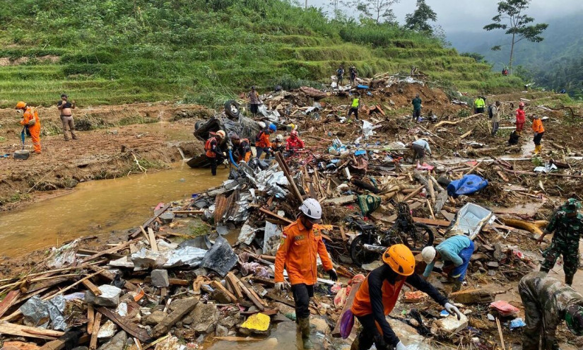
The landslide that occurred in Pekalongan on Tuesday (Jan. 21) claimed many victims, with 22 people dead and four still missing.
Search efforts for the unaccounted-for are still ongoing. This incident followed heavy rains that hit Petungkriyono District, Pekalongan Regency, Central Java Province.
The primary cause of this landslide was the extremely high intensity of rainfall. Satellite data indicated several days of rainfall before the landslide, with the highest intensity reaching 93 mm/day.
Some studies suggest that rainfall of 30 mm per day or 63 mm over three days could trigger landslides on Java. Environmental conditions like land-use changes may have also contributed to this landslide.
Professor Wahyu Wilopo, a Geology Engineering lecturer at the Faculty of Engineering, Universitas Gadjah Mada (FT UGM), emphasized that the landslide disaster in Pekalongan highlights the importance of implementing mitigation efforts.
These efforts are particularly crucial for disasters triggered by hydrometeorological conditions like landslides, floods, and storms, which have been increasing year by year.
“Their frequency and impact continue to rise, driven by global climate change,” Professor Wilopo said on Friday (Jan. 24).
Regarding the cause of the landslide, the professor explained that the location at the foot of a slope is characterized by a colluvial fan morphology (loose sediment) with steep slopes and relatively loose materials.
“The rock formations in Petungkriyono consist of volcanic rocks and deposits from past collapses, made up of clay to boulders,” he said.
He further explained that the area’s geological structure features several faults, both normal and strike-slip.
“This condition accelerates the weathering process, resulting in thick soil deposits in some areas,” he explained.
For those living in landslide-prone areas, Professor Wilopo suggested several strategies to safeguard themselves, including recognizing and understanding the risks in the surrounding area, whether for locals or newcomers.
He also advised identifying safe, non-isolated areas and the shortest, safest evacuation routes.
“If there are signs of a landslide or prolonged rain, even if not heavy, it is best to evacuate independently to a safe location. If seeking shelter or taking a rest, choose a location away from potential landslide zones,” Professor Wilopo advised.
Some of the warning signs that people should be aware of include cracks in the ground, tilted poles or trees, and deteriorating building structures. Additionally, the emergence of cloudy water springs at the foot of a slope and falling soil or rocks from the slope could signal danger.
“Usually, there will be vibrations and rumbling sounds before a large landslide occurs,” he added.
Professor Wilopo noted that many early detection warning systems have been developed to prevent casualties from landslides, including those from UGM, which have been implemented in various regions across Indonesia.
The Early Warning System (EWS) has been standardized under SNI 8235:2017 regarding the Landslide Early Warning System and ISO 22328-2:2024 Guidelines for implementing a community-based early warning system for landslides.
Equally important, he emphasized, is that both the government and the public follow updates from the Meteorology, Climatology, and Geophysical Agency (BMKG), which regularly provides forecasts of heavy rainfall for various regions in Indonesia as a warning.
Furthermore, BMKG has already shared monthly landslide threat maps with local areas. The challenge is to ensure that these warnings reach all residents at risk of landslides.
“Local governments must respond to this information quickly, accurately, and within the right time frame. There must be a solid collaboration between the government, the public, private sector, media, and academia for this mitigation effort,” he concluded.
Author: Jelita Agustine
Editor: Gusti Grehenson
Post-editor: Afifudin Baliya
Photo: Kompas