• News Archive
  • Simaster
  • Webmail
  • Directory
  • Crisis Center
  •  English
    • Indonesia
Universitas Gadjah Mada Universitas Gadjah Mada Universitas Gadjah Mada Universitas Gadjah Mada
  • Education
    • Doctoral dissertation
    • Inauguration of Professor
    • Graduation
  • Achievement
  • Research and Innovation
    • Research
    • Innovation
  • Campus Info
    • Cooperation
    • Seminar and Workshop
    • Student Community Service Program
    • Other
  • News Report
  • Home
  • News Report
  • UGM Students Make Apps for Post-Disaster Crisis Mapping

UGM Students Make Apps for Post-Disaster Crisis Mapping

  • 25 May 2016, 08:20 WIB
  • By: Marwati
  • 2077
Mahasiswa UGM Kembangkan Aplikasi Pemetaan Krisis Pasca Bencana Gempa

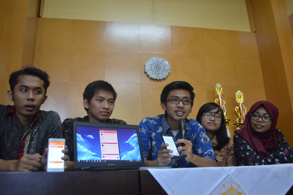
Five Engineering students of Universitas Gadjah Mada develop an Android based application to enable disaster response more easily given. The app, “Seismo Sense” is developed by Tegar Pualam Syuhada, Putri Azizah, and Rais Afif (Geodesy), Brigitta Petra (Civil Engineering), and Fransiskus Anindita Kristiawan Pramana Gentur Sutapa from Informatics Technology study programme.

“This application enables the people to report information on the number of casualties, displaced persons, and damage due to earthquake,” said chairman team, Tegar Pualam, on Tuesday (24/5) at UGM.

Tegar said the idea started from the concerns over Indonesia’s condition that is vulnerable to disasters, including earthquakes. The geographic location of the country in the Ring of Fire makes Indonesia prone to earthquake and tsunami. Not a few casualties, material losses and others have been impacted due to these disasters.

Meanwhile, the efforts to collect data and information on number of casualties, displaced persons, and damage take more time. One reason is that the input method done by volunteers is still manual. Hence, they took the initiative to make an app that enables the government in assessing casualties and damage due to disasters.

“By this application, the community can report information on casualties, position of casualties, damage, and pictures of damage in real time,” he explained.

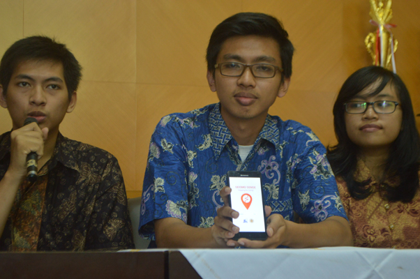
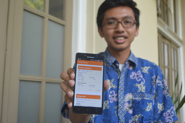
Fransiskus explained the programme starts from database search that are obtained from related agencies, such as the Regional Disaster Mitigation Agency, as well as consultation with the Rapid Response team when a disaster strikes. A software is also made to collect data quickly and accurately. There are two assessments of data, being logistical emergency and reconstruction rehabilitation. Through these menus people may report the latest condition affected by the earthquake.

The operation of the app is simple. You only need to activate the geolocation on the mobile set. Automatically, the data will go to the Seismo Sense server. Information of the disaster reporting can be presented in detail, for example, the number of casualties, level of damage, and quick aid  as well as coordinates of the disaster location.

"Important points of all data are visualised on an online dynamic map. The data will be presented in line with cartographic standards that enable analysis process for decision making,” he said.

Fransiskus said the app would not only increase community’s contribution to report post-disaster condition of an area, but also helps the government in the mapping of an area efficiently to support policy making for emergency response, rehabilitation, and reconstruction.

Related News

  • Remote Sensing Important for Disaster Mitigation

    Monday,17 October 2016 - 9:20
  • Jejak Medis Apps Help Disaster Patients Store Medical Records

    Wednesday,15 May 2019 - 13:29
  • UGM Applies Disaster Information Application

    Wednesday,04 October 2017 - 8:13
  • Jakarta Needs to Do Risk Study on Crisis and Disaster Urgently

    Monday,14 February 2011 - 14:09
  • Schools Should Be Designed As Shelters

    Tuesday,06 March 2012 - 14:02

News Releases

  • UGM Medicine Faculty & ANU Indonesia Project Launch In Sickness and In Health: Diagnosing Indonesia 07 February 2023
    UGM Faculty of Medicine, Public Health, and Nursing and Au
    Salma
  • UGM Students Create Mobile App to Inform Location Accessibility 07 February 2023
    UGM students have developed a mobile application that can
    Salma
  • Geography Alumna’s Aromatic Telon Oil Habbie Named 2023 Indonesia Brand Champion 03 February 2023
    Novita Anggraeni, an alumna of the UGM Faculty of Ge
    Salma
  • Bimasakti UGM Kicks Off Hybrid Technology Research 03 February 2023
    Bimasakti UGM has started researching hybrid technol
    Salma
  • 18,964 UGM Students Receive Scholarships, Director of Student Affairs Says 20 January 2023
    Universitas Gadjah Mada (UGM) annually allocates hundreds
    Salma

Event

No latest event at this time

Universitas Gadjah Mada
UNIVERSITAS GADJAH MADA
Bulaksumur Yogyakarta 55281
   info@ugm.ac.id
   +62 (274) 588688
   +62 (274) 565223
   +62 811 2869 988

PARTNERSHIP

  • Alumni
  • International Affairs

ABOUT UGM

  • Rector's Welcome
  • History
  • Vission and Mission
  • The Board of Executive
  • Management

VISIT UGM

  • Campus Map
  • Event

REGISTRATION

  • Undergraduate
  • Graduate
  • Vocational School
  • Professional Program
  • International Program

© 2023 Universitas Gadjah Mada

PRIVACY POLICYCONTACT