• News Archive
  • Simaster
  • Webmail
  • Directory
  •  English
    • Indonesia
Universitas Gadjah Mada Universitas Gadjah Mada Universitas Gadjah Mada Universitas Gadjah Mada
  • Education
    • Doctoral dissertation
    • Inauguration of Professor
    • Graduation
  • Achievement
  • Research and Innovation
    • Research
    • Innovation
  • Campus Info
    • Cooperation
    • Seminar and Workshop
    • Student Community Service Program
    • Other
  • News Report
  • Home
  • News Report
  • UGM Drone Succeeds in Mapping Mt. Agung Crater

UGM Drone Succeeds in Mapping Mt. Agung Crater

  • 20 October 2017, 16:30 WIB
  • By: Marwati
  • 1514
  • PDF Version
Drone UGM Sukses Memetakan Kawah Gunung Agung

A drone, owned by the Department of Geodesy Engineering, Faculty of Engineering, Universitas Gadjah Mada succeeded in mapping the areas around the slopes of Mt. Agung in Bali. The team from the Geodesy Engineering department were dispatched to Mt. Agung upon a direct request from the National Disaster Mitigation Agency (Indonesian acronym: BNPB). Collaborating with UGM’s Disaster Response Unit (DERU) and BNPB, the team made a map of the areas around Mt. Agung. Led by the Head of Drone Team from the Department of Geodesy Engineering, Ruli Andaru, S.T., M.Eng., drone Buffalo FX-79 was flown on Thursday (19/10) from Kubu village road which is located within 11 kilometers of the peak of Mt. Agung.

The mapping of the slope areas was started from an altitude of 700 meters and the team succeeded in making a map covering an area of 1,000 hectares which includes the Area Prone to Disaster I and Area Prone to Disaster II. The windy conditions became the main hurdle in this mapping. The strong wind caused turbulence for the drone. Fortunately, Buffalo FX-79 succeeded in reaching its highest altitude point at the fourth attempt. Buffalo FX-79 succeeded in flying at an altitude of 4,000 meters, while the total height of Mt. Agung is only 3,142 meters above sea level. It surpassed the drone of the Koax Flyer team from Jakarta, which previously had only reached an altitude of 1,400 meters.

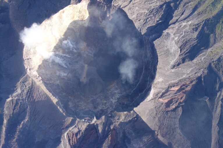
At the altitude of 4,000 meters, Buffalo FX-79 succeeded to take a picture of Mt. Agung covering an area of 3.5 x 5 kilometer. At least 400 pictures were successfully taken by the drone. According to Ruli, those pictures include visuals of the crater, both of the crater’s cracks, the crater’s material, and the crater’s fluid. Ruli said those pictures will be processed using the photogrametric method, in order to produce mosaic pictures and Digital Terrain Models (DTM).

“The team has taken pictures that can be used to predict the lava flows on the slope areas,” said Ruli Andaru.

In the near future, the drone team will try to take video-based pictures. Ruli said this video-based method will produce a different mapping.

“Using video, the mapping coverage will be wider and we can recognize the interaction or activities happening around the crater, including the smoke’s direction and so forth,” said Ruli.

Related News

  • UGM Students Initiate Drone Making Business

    Thursday,22 June 2017 - 13:39
  • UGM Sends Survey Team to Dieng

    Thursday,09 June 2011 - 8:53
  • UGM Vocational School Creates 3D Digital Documentation of Prambanan Temple

    Tuesday,01 September 2020 - 18:22
  • Seven UGM Students Climb Mt. Tambora

    Tuesday,23 August 2016 - 15:52
  • Seven UGM Students Climb Mt. Tambora

    Tuesday,23 August 2016 - 15:52

News Releases

  • Agricultural Engineering Students Grab Medals at 2022 AE-ARC 20 May 2022
    UGM Agricultural Engineering students won four medals and
    Salma
  • UGM Students Win International Chess Tournament 19 May 2022
    UGM representatives have been named winners at the 25th GA
    Salma
  • UGM Researchers Breed New Black Soybean Cultivar 17 May 2022
    A team of researchers at the UGM Faculty of Agriculture is
    Salma
  • UGM Inaugurates New Professor of Chemical Engineering 13 May 2022
    Universitas Gadjah Mada (UGM) celebrated the promotion of
    Salma
  • UGM Among World’s 10 Best Universities to Deliver SDG 1 10 May 2022
    Universitas Gadjah Mada (UGM) was ranked in the top 10 glo
    Salma

Info

  • Install Fest Windows
    29 September 2017
  • Streaming Author Workshop Writing and Publishing
    14 July 2017
  • Hokkaido University Short Term Exchange Program HUSTEP
    08 January 2016
  • 2016 Amgen Scholars Program in Japan
    08 January 2016
  • Jardine Foundation Scholarship for Postgraduate Studies at University of Oxford and University of Cambridge
    01 July 2015

Event

  • 30May International Academic Conference on Tourism (INTACT) 2022 ...
  • 21Jul The International Conference on Sustainable Environment, Agriculture, and Tourism (ICOSEAT)...
  • 07Sep The 8th International Conference on Science and Technology (ICST 2022)...
Universitas Gadjah Mada
UNIVERSITAS GADJAH MADA
Bulaksumur Yogyakarta 55281
   info@ugm.ac.id
   +62 (274) 588688
   +62 (274) 565223
   +62 811 2869 988

PARTNERSHIP

  • Alumni
  • International Affairs

ABOUT UGM

  • Rector's Welcome
  • History
  • Vission and Mission
  • The Board of Executive
  • Management

VISIT UGM

  • Campus Map
  • Event

REGISTRATION

  • Undergraduate
  • Graduate
  • Vocational School
  • Professional Program
  • International Program

© 2022 Universitas Gadjah Mada

PRIVACY POLICYCONTACT