

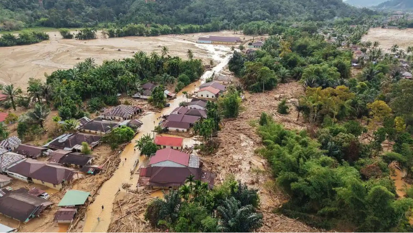
Flash floods and landslides that struck three provinces in Sumatra—Aceh, North Sumatra, and West Sumatra—up to Friday morning (Dec. 5) resulted in 836 fatalities, 509 people missing, and 2,700 injured. The disaster is believed to stem from decades of massive deforestation that have severely damaged upstream watersheds, weak law enforcement, and increasing hydrometeorological risks.
These issues were discussed in a recent forum titled “Forest Management and Disaster Mitigation” held at the Auditorium of the Faculty of Forestry, Universitas Gadjah Mada (Forestry UGM). The discussion brought together several experts to examine the root causes of the disaster and explore future mitigation strategies from geospatial, forestry policy, watershed management, spatial planning, and social forestry perspectives.
Dr. Hatma Suryatmojo, a forest hydrology researcher at Forestry UGM, explained that the Sumatra floods resulted from a fatal interaction between extreme weather and fragile forest ecosystems. Nature’s ability to mitigate disaster impacts has declined due to extensive deforestation, land-use conversion, and spatial planning that fails to consider disaster vulnerability.
“Extreme rainfall was indeed a trigger, but the real root of the problem lies in the systematic destruction of upstream-to-downstream watershed ecosystems and negligence in spatial planning,” he said.
Dr. Suryatmojo recommended breaking the disaster cycle through a dual strategy: ending deforestation and protecting remaining forest areas, as well as rehabilitating watersheds and accelerating reforestation. He added that technical and social approaches are equally essential, including risk-based spatial planning, early warning systems, education, and community engagement.
“This disaster is not a natural failure but a failure to implement and enforce existing conservation and spatial planning regulations,” Hatma added.
Dr. Belinda Arunarwati Margono from the Geospatial Information Agency (BIG) agreed with Dr. Suryatmojo’s assessment, noting that the disaster had multiple causes, including geomorphological and soil conditions, extreme weather, and anthropogenic factors. Communication gaps between regional and central governments have also hindered an effective response.
“Although early detection systems exist, weak communication and limited understanding between central and regional governments mean there is no proper mechanism or sufficient awareness to act on the warnings,” she said.
Professor San Afri Awang of Forestry UGM highlighted that oversight of forest governance remains weak due to poor coordination between regional and national authorities. He pointed out that local governments often fail to enforce fundamental regulations, such as the Soil and Water Conservation Law, which, in some cases, is not even included in regional budgets. He emphasized the urgency of addressing this serious issue.
Meanwhile, Professor Ambar Kusumandari, a soil and water conservation expert from the same faculty, discussed watershed management dimensions of the disaster. She noted that, based on watershed morphometric data, four of the 10 watersheds studied in the affected regions already had high disaster potential. Soil conditions in these areas, crossed by geological faults, also increase the risk of landslides following earthquakes.
“With rapid deforestation, hydrometeorological disasters will continue to rise, leading to severe consequences such as biodiversity loss and declining water reserves,” she explained.
Another Forestry UGM scholar, Professor Ahmad Maryudi, emphasized that deforestation in national parks across Sumatra is largely driven by anthropogenic factors, including human actions and negligence. He added that poor-quality policies, compounded by weak implementation capacity, have worsened the situation.
“It is undeniable that deforestation contributes to these disasters, but it is an accumulation of decades of policy inflation and capacity collapse,” he stressed.
Author: Jesi
Editor: Gusti Grehenson
Post-editor: Salma
Photograph: Salwa & Jesi