


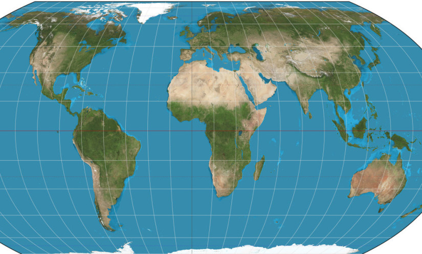
The United Nations (UN) has endorsed the Equal Earth map projection to present the relative sizes of continents more proportionally, particularly Africa. Although the UN’s decision is not an absolute mandate, the resolution is encouraging several international organizations to shift from the Mercator projection to Equal Earth.
Dr. Ari Cahyono, Head of the Cartography Laboratory at UGM’s Faculty of Geography (Geography UGM), explained that differences in how regions appear on world maps are related to the map projection used. A map projection is a method of representing Earth’s curved surface on a flat plane. This process inevitably introduces distortion or changes in certain aspects, such as shape, area, distance, and angles.
“Distortion is inevitable when a curved surface is represented on a flat plane. This means no map can be 100% accurate in every aspect. It is impossible to preserve the shapes and areas of regions, distances, and angles all at once,” he explained on Friday, October 9.
Mercator and Equal Earth
Gerardus Mercator developed the Mercator projection in the 16th century to support maritime navigation. It preserves direction and angles, helping sailors determine their routes. However, this characteristic causes area distortion to increase at higher latitudes, farther from the equator.
As a result, regions such as Greenland and Antarctica appear much larger than they are in relative terms. Other regions, including North America and Europe, also appear larger than they would on an equal-area projection. Meanwhile, areas near the equator experience relatively less area distortion.
According to Ari, the characteristics of the Mercator projection cannot be separated from its original purpose. It remains useful for navigation because it preserves angles and directions, but it is less suitable for directly comparing the areas of different regions.
“If a map is intended for maritime navigation, Mercator remains a good choice. However, if the aim is to shape people’s perceptions of different regions and help them develop a consistent understanding of their actual relative sizes, Equal Earth is more suitable,” he explained.
Unlike Mercator, Equal Earth is a world map projection designed to preserve the proportional areas of regions. It allows people to compare the sizes of continents and countries without the characteristic area distortion associated with Mercator.
Equal Earth also affects how people understand regions’ positions and sizes on a world map. Ari noted that visual representations can influence people’s perceptions of geography. When a region appears larger than its actual relative area, map readers may develop an inaccurate understanding of how it compares with other regions.
“Because maps are visual representations, we must consider human visual perception. How we interpret a map can certainly influence how we perceive the regions we imagine,” he said.
He added that the push to use equal-area projections is also related to efforts to represent regions more equitably. With Equal Earth, Africa’s area can be compared more proportionally with that of other continents, helping people move beyond impressions created by particular map projections.
Although Equal Earth offers advantages for comparing areas, Ari emphasized that it is not automatically better than Mercator for every purpose. The choice of projection must account for the map’s purpose, the location being mapped, the map scale, and the geographical properties that need to be preserved.
He explained that different map projections are developed for different characteristics and uses. Azimuthal projections, for example, can map polar regions. Cylindrical projections suit certain mapping needs near the equator, while conic projections are often used for mid-latitude regions.
“No single map projection is suitable for every purpose. A projection cannot meet every mapping need,” he stressed.
In Indonesia, where most of the country lies near the equator, the choice of world map projection should be tailored to its intended use. If a map is used for educational purposes and to help students understand the relative areas of continents, Equal Earth may be an appropriate option. However, other projections may be more suitable for navigation or technical mapping.
Dr.Ari also emphasized the importance of involving professional cartographers in mapmaking. The choice of projection must account for acceptable distortion levels to ensure the information presented meets users’ needs. In Indonesia, the Geospatial Information Agency (BIG) provides base maps that serve as references for various mapping activities.
Understanding the Limitations of Digital Maps
Understanding map distortion is also relevant amid the widespread use of digital mapping services such as Google Maps. Ari explained that people need to understand the projection system used before interpreting map information. Differences in map projections and geodetic datums can affect how locations are represented and how measurements are calculated.
Google Maps uses the Web Mercator projection for its map display. This system supports global digital mapping, but it still has limitations, particularly when representing areas at high latitudes. As a result, the way a region appears on a screen does not always reflect its actual relative area.
In addition, differences between distances shown on a map and distances on the ground can be affected by the map scale, coordinate system, datum, and measurement method. Users need to distinguish between maps intended to provide a general overview of an area, navigation maps, and technical maps designed for specific measurement purposes.
Ari reminded the public that simply looking at a map’s visual appearance is not enough; people also need to understand its intended purpose. A good map is not entirely free of distortion, but one that presents information accurately in accordance with users’ needs.
“Every map contains some distortion because the Earth is spherical and must be projected from three dimensions onto two. However, certain aspects can be preserved depending on the purpose of the map,” he concluded.
Therefore, Equal Earth and Mercator should each be used for their intended purposes. Equal Earth helps present proportional comparisons of regional areas, while Mercator remains relevant for certain navigation needs. Understanding each projection’s characteristics is essential for reading maps critically and developing a more accurate understanding of geography.
Author: Zabrina Kumara
Editor: Gusti Grehenson
Post-Editor: Priyananda
Photo: Wikimedia